
Bob Swenson Memorial Field is OCMA’s flying site in Silverado, California, on County Parks land. Field hours are 8:00 AM to sunset. This page is how to get there, what you must have on you to fly, and the airspace and field rules that keep the site open.
An OCMA badge is required to fly. See Membership for the application. History of the field is on About.
Location
| Fact | Detail |
|---|---|
| Field | Bob Swenson Memorial Field |
| Area | Silverado, CA |
| Address | 5305 Santiago Canyon Road |
| Access road | Blue Diamond / Haul Road to the end |
| GPS | 33°46′18.07″N, 117°41′52.79″W |
| Decimal | 33.7717, −117.6980 |
| Hours | 8:00 AM – sunset |
Open in OpenStreetMap · Open in Google Maps
Directions
The field is not on Santiago Canyon Road itself. Turn onto Blue Diamond Road (also called Haul Road) and stay on the paved road about one mile to the brown steel gate. Blue Diamond is unsigned. Look for the yellow park signs for Baha Beach Park, Little Oak Park, and Big Oak Park.
From north Orange County
Take the 22 east to the 55. Exit at the first opportunity, Chapman Avenue eastbound. Continue about 5 miles to the toll-road onramps, where Chapman becomes Santiago Canyon Road. Continue east about 2 miles to the Irvine Lake entrance on your left. Keep going about 3/4 mile to the next left. Turn left through the gate onto Blue Diamond Road and follow the pavement 1 mile to the brown steel gate.
From south Orange County
Take a non-toll freeway north to El Toro Road. Continue east about 5 miles to Santiago Canyon Road at Cook’s Corner. The road veers left and becomes northbound Santiago Canyon. Continue about 13 miles, past the railroad bridge, to Blue Diamond Road. Turn right through the gate and follow the pavement 1 mile to the brown steel gate.
If you reach the Irvine Lake entrance, you missed the right turn. Turn around and take Blue Diamond on the other side of the canyon road.
Required to fly
Safety Officers, Field Marshals, and Board officers can check this. Aircraft without the proper FAA number will not fly until it is displayed. AMA identification inside the aircraft is still required by AMA.
- OCMA membership badge worn on your person (current rules sticker on the badge)
- FAA registration card on your person
- FAA number displayed on the aircraft you intend to fly
- AMA Full Membership (card or proof)
- Class A fire extinguisher with you at the field
Airspace
Stay inside the defined airspace at all times. That is a County Parks and association requirement, not a suggestion. Aircraft have been seen over the river to the north and up the valley past the eastern boundary. If you have trouble judging it, use a spotter.
- West and east: fly within the tree line
- North: use the oak tree across the field as the boundary — do not fly over the river
- East: do not continue up the valley past the posted boundary
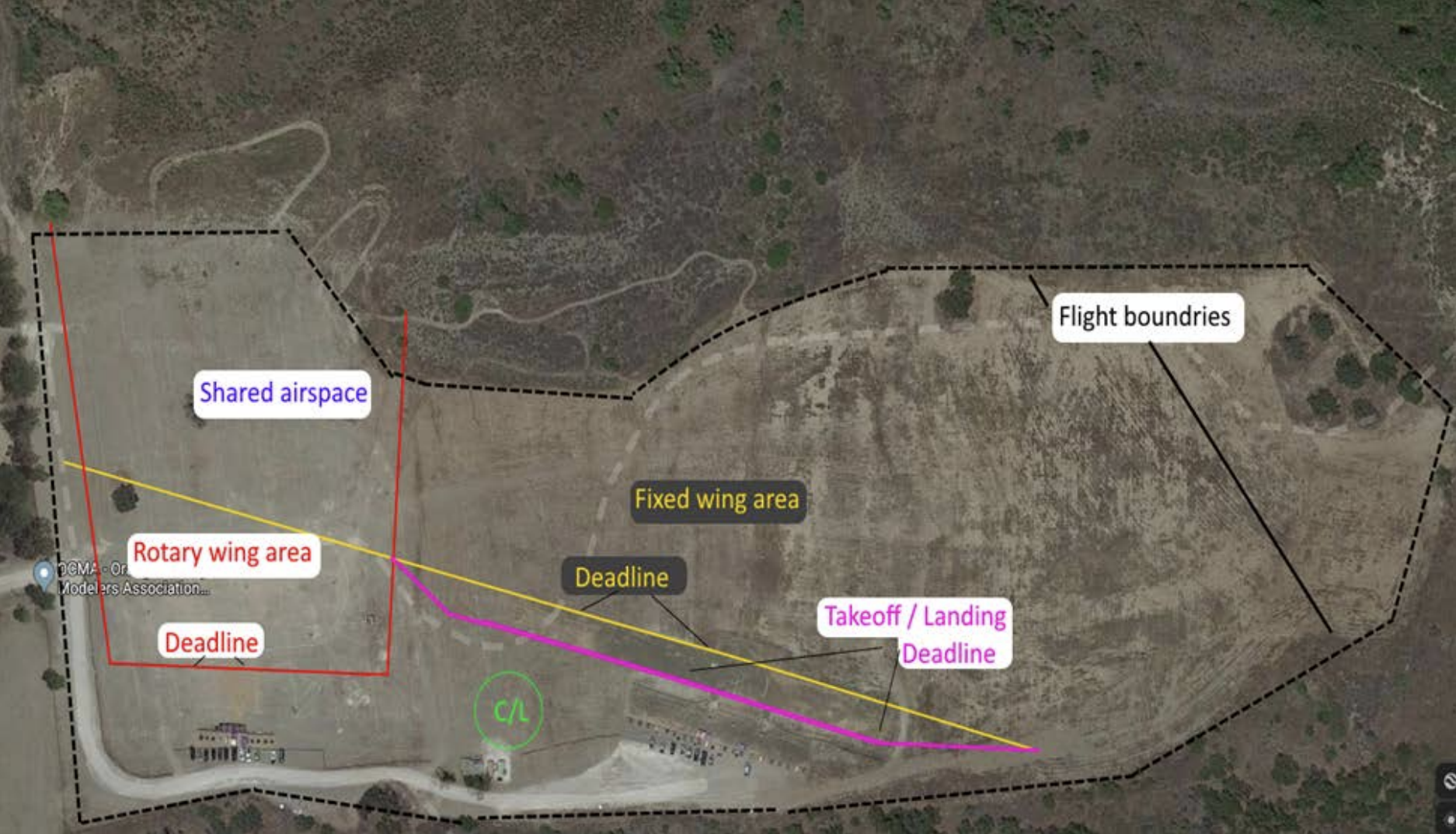
How to read the map:
- Black dashed line — overall flight boundaries
- Red — rotary wing area and rotary deadline
- Yellow — fixed wing area and fixed-wing deadline
- Pink — takeoff / landing deadline
- Blue — shared airspace
- Green C/L circle — control line
The same map is posted on the bulletin board at the field.
Weather, fire, and alerts
For current weather at the field, use the SCE stations map and select the Haul Rd station. Check fire weather before you go; the canyon can close the field.
- SCE weather stations — choose Haul Rd
- NWS forecast / fire weather for the field
- Email alerts: write OCMAAlerts@flyocma.com and ask to be added. Closures and last-minute field notices also go on Notices.
Protected habitat
The land around the field is protected habitat. Do not walk out after an aircraft on your own. Read aircraft retrieval from protected habitat on the current OCMA site before you fly.
FPV
FPV flying is allowed only under OCMA’s FPV rules. Read the FPV frequency rules and the special notice for FPV pilots before you fly FPV at the field.